Have you been searching for London Zip Codes but can’t find them? That’s because the United Kingdom doesn’t use zip codes but instead uses postal codes, also known as postcodes.
The postcodes in the UK incorporate letters and numbers used by the Royal Mail for its delivery system in the country.
In total, the UK uses 121 postcode areas and three postcodes for the Crown Dependencies of Jersey, Guernsey, and the Isle of Man.
In every postcode area, there is a postcode district, and within each postcode district, there are a number of postcode sectors. Overall, there are 30 million postal addresses in the UK and 1.8 million postcodes.
The postcode areas and districts in Greater London comprise eight inner London postcode districts and 15 outer London postcode districts.
The eight inner London postcode districts cover 241 square miles of England.
In this article, I focus on the eight inner London postcode districts and areas: E, EC, N, NW, SE, SW, W, and WC.
After reading this quick London Postcode guide, you’ll learn about the following:
- What Are the Parts of a London Postcode
- What Is London Zip Code or Postcode
- List of London Postcode Areas
- How to Know Your Postcode in London
Further Reading for UK postcodes.
- To learn more about Zip Code In The Uk, Check out our detailed guide to Uk Postcode.
- Want to learn how to write a postcode in the UK? Here is our guide to the UK postcode format.
- Download the UK Postcode Map in case you want to check the postcode in the UK offline.
- Here is a list of Area Postcodes UK if you want to check the area postcodes quickly.
Contents
What Are the Parts of a London Postcode
The postcode is made up of an outward and inward code. The outward code is the first part of the postcode that includes two to four alphanumeric codes indicating the post town or district.
The second part is the inward code, comprising three alphanumeric codes to identify the postcode sector and delivery point.
Here are some examples of what London postcodes look like:
| E1 0AA (Lukin Street) | E1 (outward) 0AA (inward) |
| EC4N 1SA (Queen Street) | EC4N (outward) 1SA (inward) |
| N1 0AA (Bemerton Estate) | N1 (outward) 0AA (inward) |
| NW1 0AU (Bayham Street) | NW1 (outward) 0AU (inward) |
| SE12 0AA (Burnt Ash Hill) | SE12 (outward) 0AA (inward) |
| SW1V 1AA (Vauxhall Bridge Road) | SW1V (outward) 1AA (inward) |
| W1S 1AN (Dering Street) | W1S (outward) 1AN (inward) |
| WC2H 0BD (Charing Cross Road) | WC2H (outward) 0BD (inward) |
Check out our guide to the UK postcode format.
What Is London Zip Code or Postcode (how does London postcode work)
Now that you know the elements of London postcodes, let’s dive deep into the areas and districts each postcode covers.
In total, London has eight postcode areas for eight districts:
- E – East London
- EC – East Central
- N – North London
- NW – North West London
- SE – South East London
- SW – South West London
- W – West End, London
- WC – West Central London
List of London Postcode Areas
Below you will find a complete table of each of the eight postcode districts and their postcode areas.
I included a map as well to help you easily locate the London postcode areas in the London regions.
As an overview, here is a London Postcode Map of both inner and outer London postcode districts.
London Postcode Map

(London Postcode Map by Richardguk via Wikimedia Commons)

(Map of Postcode Districts in Central London by Richardguk via Wikimedia Commons)
East London Postal Code
East London uses the postcode area “E”. It has one post town, 22 postcode districts, and 108 postcode sectors. It is bordered by the following postcode areas, N, EN, IG, and SE.
| Postcode Area | Postcode District | District and Area (whole or partial coverage) |
| E | E1
Eastern Head District |
Aldgate, Bishopsgate, Limehouse, Mile End, Portsoken, Shoreditch, Spitalfields, Shadwell, Stepney, Whitechapel |
| E1W
Wapping District |
St. Katharine’s and Wapping, Stepney, Shadwell, Whitechapel | |
| E2
Bethnal Green District |
Bethnal Green, Cambridge Heath, Globe Town, Haggerston, Hoxton, Shoreditch | |
| E3
Bow District |
Bow, Bow Common, Bromley-by-Bow, Old Ford, Mile End Park Leisure Centre and Stadium, Fish Island, Hackney Wick, South Bromley, Tower Hamlets Cemetery Park, Mill Meads | |
| E4
Chingford District |
Chingford, Chingford Hatch, Chingford Mount, Highams Park, West Essex Golf Club, Waltham Abbey, Sewardstone, Highams Park, Woodford Green | |
| E5
Clapton District |
Leyton, Upper Clapton, Lower Clapton, Stoke Newington, Millfields Park, Hackney Marshes, North Millfields Recreation Ground | |
| E6
East Ham District |
East Ham, Central Park, East Ham Jewish Cemetery, Beckton, Upton Park, Barking | |
| E7
Forest Gate District |
Forest Gate, Manor Park Cemetery and Crematorium, Leytonstone, Wanstead park, Stratford | |
| E8
Hackney District |
Hackney, Haggerston, Hackney Central, Dalston, London Fields, Stoke Newington, Blackstone Estate | |
| E9
Homerton District |
Well Street Common, Wick Woodland, Homerton, Hackney Wick, South Hackney, Hackney Marshes, Victoria Park | |
| E10
Leyton District |
Leyton Grange Estate, Leyton, Temple Mills, Hackney Marshes, Walthamstow Marshes | |
| E11
Leytonstone District |
Bushwood, Leytonstone, Wanstead, Snaresbrook | |
| E12
Manor Park District |
Aldersbrook, Manor Park, Little Ilford, City of London Cemetery and Crematorium, | |
| E13
Plaistow District |
Plaistow, West Ham, Upton Park, Upton, Greengate | |
| E14
Poplar District |
Blackwall, Poplar, Isle of Dogs, Leamouth, Aberfeldy Village, Limehouse, Canary Wharf, Millwall, Cubitt Town, South Bromley, North Greenwich | |
| E15
Stratford District |
Queen Elizabeth Olympic Park, Stratford, West Stratford City, West Ham, Maryland, Leyton, Leytonstone, Mill Meads | |
| E16
Victoria Docks and North Woolwich District |
Canning Town, Beckton District Park South, Silvertown, Limo Peninsula, Royal Docks, North Woolwich, Beckton, London City Airport | |
| E17
Walthamstow District |
Walthamstow, Upper Walthamstow, Leyton Grange Estate | |
| E18
Woodford and South Woodford District |
Woodford, South Woodford | |
| E20
Olympic Park District |
Bow, Olympic Park, Stratford, Homerton, Leyton, | |
| E77
Non-geographic postcode District |
NatWest | |
| E98
Non-geographic postcode District |
News International |

(E Postcode Area Map by Richardguk via Wikimedia Commons)
East Central London Postal Code
East Central London uses EC as its postcode area. It covers Central London and a majority of the City of London. Some London Congestion Charge Postcodes are among the EC postcodes.
It is also often referred to as the London EC postal area, which includes one post town, 30 postcode districts, and 140 postcode sectors.
| Postcode Area | Postcode District | District and Area (whole or partial coverage) | |
| EC
|
EC1 Head District
|
EC1A | St Bartholomew’s Hospital, Barbican, St. Bartholomew the Great |
| EC1M | Clerkenwell, Farringdon, Golden Lane Estate, The Charterhouse | ||
| EC1N | Hatton Garden, Charterhouse St. | ||
| EC1P | Non-geographic | ||
| EC1R | Clerkenwell, Finsbury, Finsbury Estate, Roseberry Ave | ||
| EC1V | Finsbury, King Square Gardens, Radnor Street Open Space, Moorfields Eye Hospital, Old Street | ||
| EC1Y | Golden Lane Estate, St Luke’s, Bunhill Fields Burial Ground | ||
| EC2 Bishopsgate
|
EC2A | Shoreditch High Street | |
| EC2M | Liverpool Street, Finsbury Circus Gardens | ||
| EC2N | Old Broad Street, Tower 42, London Wall | ||
| EC2P | Non-geographic | ||
| EC2R | Bank of England, London Wall | ||
| EC2V | Guildhall, Guildhall Art Gallery | ||
| EC2Y | Barbican, Barbican Estate, Moorgate | ||
| EC3 Fenchurch Street
|
EC3A | St Mary Axe, Aldgate, Dukes Pl, White Kenneth St. | |
| EC3M | Lloyd’s of London, Fenchurch Street, The Garden at 120 | ||
| EC3N | Tower Hill, Tower of London, London Wall, American Square | ||
| EC3P | Non-geographic | ||
| EC3R | Monument, Billingsgate, St. Dunstan in the East Church Garden, St. Olave’s Church Hart Street, Fenchurch Street | ||
| EC3V | Cornhill, Leadenhall St., Fenchurch St., Lime Street | ||
| EC4 Fleet Street
|
EC4A | New Fetter Ln, Farringdon St, St. Andrew St, Dr. Johnson’s House | |
| EC4M | St Paul’s Cathedral, St. Paul’s, Mansion House, Central Criminal Court | ||
| EC4N | London Mithraeum, Bank, Mansion House, Puttshack Bank | ||
| EC4P | Non-geographic | ||
| EC4R | Monument, Cannon Street, Monument to the Great Fire of London, Lower Thames St. | ||
| EC4V | Blackfriars, Mansion House, Upper Thames St., Ludgate Hill | ||
| EC4Y | Blackfriars, Blackfriars Upas, City Thameslink, Inner Temple Gardens | ||
| EC50 | Non-geographic |
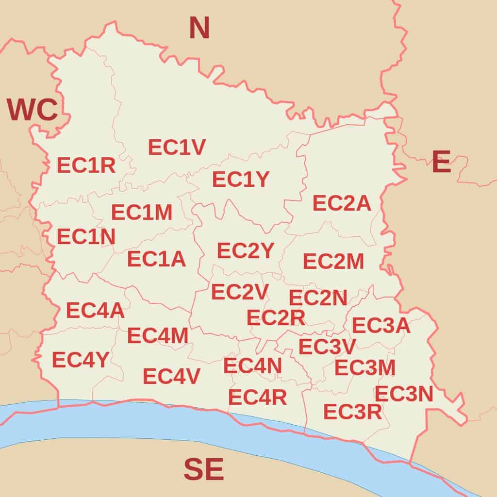
(EC Postcode Area Map by Richardguk via Wikimedia Commons)
North London Postal Code
North London or London N postcode area covers one post town and 25 postcode districts.
Moreover, there are 112 postcode sectors under the N postcode area. The London boroughs included in the postcode area are Barnet, Camden, Enfield, Hackney, Haringey, and Islington.
| Postcode Area | Postcode District | District and Area (whole or partial coverage) |
| N | N1
Northern head District |
Colville Estate, Whitmore Estate, Barnsbury Estate, The Angel, Canonbury, Kings Cross, Islington, Pentonville, De Beauvoir Town, Liverpool Rd, Arden Estate |
| N1C | Kings Cross Central, Kings Cross St. Pancras, Canal Reach, York Wy, Camley Street Natural Park | |
| N1P | N1 and N1C PO Box | |
| N2
East Finchley District |
Islington and St. Pancras Cemetery, East Finchley Cemetery, East Finchley, Lyttelton Playing Fields, Hampstead Garden Suburb | |
| N3
Finchley District |
Finchley, Finchley Central, Church End, Victoria Park, West Finchley | |
| N4
Finsbury Park District |
Finsbury Park, The Castle Climbing Centre, Manor House, Harringay Warehouse District, Harringay Green Lanes, | |
| N5
Highbury District |
Highbury Square, Highbury Fields, Arsenal | |
| N6
Highgate District |
Highgate, Highgate Golf Club, Waterlow Park, Hampstead Heath | |
| N7
Holloway District |
Market Estate, Hilldrop Estate, Caledonian Road, Holloway, Barnsbury, Finsbury Park, Highbury and Islington, Tufnell Park | |
| N8
Hornsey District |
Hornsey, Priory Park, Crouch End, Stationers Park | |
| N9
Lower Edmonton District |
Claverings Industrial Estate, Lee Valley Leisure Complex, Lower Edmonton, Edmonton | |
| N10
Muswell Hill District |
Muswell Hill, Queen’s Wood, Friern Barnet | |
| N11
New Southgate District |
New Southgate, Friern Barnet, Bounds Green, New Southgate Cemetery and Crematorium, Arnos Grove | |
| N12
North Finchley District |
North Finchley, Woodside Park, Friern Barnet | |
| N13
Palmers Green District |
Broomfield Park, Palmers Green, Tottenhall Recreation Ground, Tatem Park Recreation Ground | |
| N14
Southgate District |
Southgate, Oakwood, Arnos Grove, Bramley Sports Ground, Grovelands Park | |
| N15
South Tottenham District |
South Tottenham, Harringay, West Green, Seven Sisters, Markfield Park, Duckett’s Green | |
| N16
Stoke Newington District |
Stoke Newington, Stamford Hill, Shacklewell, Dalston, Newington Green, Clissold, Abney Park, Upper Clapton, Stamford Hill | |
| N17
Tottenham District |
Tottenham, Little Russia, Bruce Castle Museum, Broadwater Farm Community Centre | |
| N18
Upper Edmonton District |
Silver Street, Pymmes Park, Upper Edmonton, Edmonton | |
| N19
Upper Holloway District |
Whittington Park, Upper Holloway, Archway, Elthorne Park | |
| N20
Whetstone District |
Whetstone, Totteridge, Oakleigh Park, Brook Farm Open Space, North Middlesex Golf Club, South Barnet | |
| N21
Winchmore Hill District |
Winchmore Hill, Bush Hill, Grange Park, Grovelands Park Play Area | |
| N22
Wood Green District |
Wood Green, Bowes Park, Alexandra Park and Palace | |
| N81 | Electoral Reform Services |

(North Postcode Area Map by Richardguk via Wikimedia Commons)
North West London Postal Code
According to data, the North West postcode area or London NW postcode area covers 13,895 live postcodes under 13 postcode districts.
There are 81 postcode sectors covering several London boroughs including Barnet, Brent, Ealing, Harrow, Ealing, Hammersmith and Fulham, Kensington and Chelsea, and the City of Westminster.
It is bounded by several postcode areas such as N, WC, W, HA, and EN.
| Postcode Area | Postcode District | District and Area (whole or partial coverage) |
| NW | NW1
North Western head District |
ZSL London Zoo, Camden Lock Market, Mornington Crescent, London Marylebone, London Euston, Regent’s Park, Baker Street, Camden Town, Somers Town, Primrose Hill and Lisson Grove, St. Pancras International, Park Square |
| NW1W | NW1 PO Box | |
| NW2
Cricklewood District |
Cricklewood, Gladstone Park, Dollis Hill, Childs Hill, Golders Green, Brent Cross, Willesden Green, Neasden, Kilburn | |
| NW3
Hampstead District |
Hampstead, Belsize Park, Frognal, Childs Hill, South Hampstead Heath, Kenwood, Swiss Cottage, The Hill Garden and Pergola, Primrose Hill, Chalk Farm, Gospel Oak, Keats House, Parliament Hill Viewpoint | |
| NW4
Hendon District |
Middlesex University London, West Hendon, Sunny Hill Park, Windsor Open Space, Hendon, Brent Cross | |
| NW5
Kentish Town District |
Kentish Town West, Kentish Town, Hilldrop Estate, Camden Town, Gospel Oak, Dartmouth Park, Chalk Farm, Tufnell Park | |
| NW6
Kilburn District |
Kilburn Grange Park, North Maida Vale, Kilburn High Road, Brondesbury, West Hampstead, Queen’s Park, Kensal Green, South Hampstead, Paddington Old Cemetery | |
| NW7
Mill Hill District |
Mill Lane, Inglis Barracks, Greenvue venue, Highwood Hill, Mill Hill East | |
| NW8
St John’s Wood District |
St John’s Wood, Lord’s Cricket Ground, Abbey Rd, Finchley Rd, Lisson Grove | |
| NW9
The Hyde District |
The Hyde, Fryent Country Park, Colindale, Kingsbury Green, West Hendon, Wembley Park, Queensbury | |
| NW10
Willesden District |
Willesden, Willesden Junction, Harlesden, Kensal Green, Kensal Rise, Brent Park, College Park, Stonebridge, North Acton, West Twyford, Neasden, Park Royal | |
| NW11
Golders Green District |
Hampstead Heath Extension, Golders Green, Golders Hill Park, Temple Fortune, Hampstead Garden Suburb, Hendon, Finchley Rd | |
| NW26 | NW10 PO Box |

(NW Postcode Area Map by Richardguk via Wikimedia Commons)
South East London Postal Code
South East London utilizes the SE postcode area. It comprises one post town, 30 postcode districts, and 129 postcode sectors. According to data, there are 20,476 live postcodes and 34,165 postcodes in total.
The Royal Borough of Greenwich and the London Boroughs of Lewisham and Southwark are some of its coverage.
| Postcode Area | Postcode District | District and Area (whole or partial coverage) |
| SE | SE1
South Eastern head District |
Bankside, South Bank, Lambeth, Lambeth North, Waterloo, London Waterloo East, Southwark, Borough, Borough Market, Bermondsey, St. Saviours Estate, Vauxhall, Peckham |
| SE1P | Non-geographic | |
| SE2
Abbey Wood District |
Abbey Wood, Lesnes Abbey, Southmere Park, West Heath, Thamesmead, Bostall Gardens, Plumstead, Bostall Heath and Woods | |
| SE3
Blackheath District |
Blackheath, Kidbrooke, Westcombe Park, Vanbrugh Park, Cator Park | |
| SE4
Brockley District |
Brockley, Hilly Fields, Crofton Park, Ladywell Fields, Telegraph Hill, Brockley and Ladywell Cemetery, New Cross gate Cutting | |
| SE5
Camberwell District |
Camberwell, Elmington Estate, Ruskin Park, Denmark Hill, Burgess Park, Peckham | |
| SE6
Catford District |
Southend, Forster Memorial Park, Catford, Bellingham, Hither Green, Rushey Green | |
| SE7
Charlton District |
New Charlton, Charlton Park, The Thames Barrier, Charlton House and Gardens | |
| SE8
Deptford District |
Deptford, Deals Gateway, Pepys Park, Folkestone Gardens, Evelyn, Rotherhithe, St John’s, Brookmill Park | |
| SE9
Eltham District |
Eltham, Eltham Palace, Mottingham, Oxleas Wood, New Eltham, Severndroog Castle, Well Hall, Coldharbour Estate, Avery Hill, Avery Hill Park, Royal Blackheath Golf Club, Chinbrook | |
| SE10
Greenwich District |
Greenwich, North Greenwich, Royal Observatory Greenwich, Cutty Sark, Blackheath Hill, Maze Hill, Greenwich Peninsula, Westcombe Park | |
| SE11
Kennington District |
Kennington, Kennington Park, Lambeth, Vauxhall, The Oval | |
| SE12
Lee District |
Bannatyne Health Club Grove Park, Mottingham, Grove Park, Northbrook Park, Chinbrook, Lee, Hither Green, Eltham, Horn Park | |
| SE13
Lewisham District |
Lewisham, Hither Green, Ladywell | |
| SE14
New Cross District |
New Cross, New Cross Gate, Telegraph Hill | |
| SE15
Peckham District |
Peckham, WillowsBrook Estate, Nunhead, South Bermondsey, Peckham Rye Park and Common | |
| SE16
Rotherhithe District |
Rotherhithe, Canada Water, Surrey Quays, South Bermondsey | |
| SE17
Walworth District |
Walworth, Cooks Rd, Kennington, Faraday Gardens, Surrey Square Park | |
| SE18
Woolwich District |
Woolwich, Royal Arsenal, Plumstead, Queen Elizabeth Hospital, Polthorne Estate, Shooter’s Hill | |
| SE19
Norwood District |
Upper Norwood, Crystal Palace, Westow Park, The Lawns, Gipsy Hill | |
| SE20
Anerley District |
Anerley, Crystal Palace, Penge, Betts Park, Birkbeck, Penge West, Penge East, Beckenham | |
| SE21
Dulwich District |
Dulwich, Kingswood Estate, Dulwich Village, Sydenham Hill Wood, Belar Park, Tulse Hill, West Dulwich | |
| SE22
East Dulwich District |
East Dulwich, Camberwell Old Cemetery, Dog Kennel Hill Estate | |
| SE23
Forest Hill District |
Crofton Park, Forest Hill, Honor Oak Perry Vale | |
| SE24
Herne Hill District |
Herne Hill, Tulse Hill, West Dulwich | |
| SE25
South Norwood District |
South Norwood, Selhurst, Thornton Heath, Woodside | |
| SE26
Sydenham District |
Upper Sydenham, Lower Sydenham | |
| SE27
West Norwood District |
West Norwood, Tulse Hill | |
| SE28
Thamesmead District |
Thamesmead, Gallions Reach Park |

(SE Postcode Area Map by Richardguk via Wikimedia Commons)
South West London Postal Code
South West postcode area covers several London boroughs including the City of Westminster, Kensington and Chelsea, Lambeth, Wandsworth, Hammersmith and Fulham, Richmond upon Thames, Croydon, and Merton.
It uses the postcode area SW, which includes one post town, 29 postcode districts, and 139 postcode sectors. The most popular postcode is SW19, which is used for Wimbledon.
| Postcode Area | Postcode District | District and Area (whole or partial coverage) |
| SW | SW1A | Constitution Hill, Buckingham Palace, St James’s |
| SW1E | Westminster, Northern Victoria | |
| SW1H | St James’s Park, Victoria St, Queen Anne’s Gate | |
| SW1P | Victoria Tower Gardens South, Millbank, Westminster Cathedral | |
| SW1V | Pimlico, Churchill Gardens, Vauxhall Bridge | |
| SW1W | Abbots Manor, Victoria Station, Eaton Square Garden of, Belgravia Park, The Royal Mews Buckingham Palace | |
| SW1X | Belgravia, Knightsbridge and Chelsea, Hyde Park Corner | |
| SW1Y | St James’s, Waterloo Gardens | |
| SW2
Brixton District |
Brixton Hill, Brockwell Lido, Tulse Hill, Brixton, Streatham Hill, Clapham | |
| SW3
Chelsea District |
Chelsea, Knightsbridge | |
| SW4
Clapham District |
Clapham, Stockwell | |
| SW5
Earls Court District |
Earls Court | |
| SW6
Fulham District |
Fulham, West Brompton, Walham Green, Hurlingham, Parsons Green, Putney Bridge | |
| SW7
South Kensington District |
South Kensington, Gloucester Road, Knightsbridge | |
| SW8
South Lambeth District |
Patmore Estate, South Lambeth, Vauxhall, Wandsworth Road, Nine Elms, Clapham North, Oval | |
| SW9
Stockwell District |
Vassal, Brixton, Stockwell, Clapham, Oval | |
| SW10
West Brompton District |
Cremorne Estate, Worlds End Estate, Chelsea Harbour | |
| SW11
Battersea head District |
Battersea, Clapham Junction, Battersea Park, Battersea Power Station, Queenstown Road, Nine Elms | |
| SW12
Balham District |
Balham, Clapham Park, Oaklands Estate | |
| SW13
Barnes District |
WWT London Wetland Centre, Barnes Bridge | |
| SW14
Mortlake District |
North Sheen, Mortlake, East Sheen | |
| SW15
Putney District |
Putney, East Putney, Roehampton, Putney Heath, Putney Vale, Queen Mary’s Hospital, Roehampton Vale | |
| SW16
Streatham District |
Streatham, Streatham Common, Norbury, Streatham Park, Streatham Hill, West Norwood | |
| SW17
Tooting District |
Tooting Bec, Grosvenor Way, Tooting Broadway | |
| SW18
Wandsworth District |
Wandsworth, Wandsworth Common, Southfields, Earlsfield | |
| SW19
Wimbledon District |
Wimbledon, Colliers Wood, Merton Park, Haydons Road, Merton Abbey, Wimbledon Park, Southfields, Morden | |
| SW20
West Wimbledon District |
Raynes Park, Cottenham Park, Bushey Mead, Lower Morden, Copse Hill, Wimbledon Chase |

(SW Postcode Area Map by Richardguk via Wikimedia Commons)
West London Postal Code
The W postcode area is used by parts of Central and Western London, specifically several boroughs such as Westminster, Camden, Kensington and Chelsea, Ealing, Hounslow, Hammersmith and Fulham, and Brent.
It is linked to other postcode areas including HA, SW, WC, NW, UB, and TW. The London W postcode area has 35 postcode districts, 217 postcode sectors, and 18,554 live postcodes.
| Postcode Area | Postcode District | District and Area (whole or partial coverage) |
| W | W1A | WI PO Boxes and Admail codes |
| W1B | Portland Place, Regent Street | |
| W1C | Oxford Street | |
| W1D | Soho, Chinatown, Soho Square | |
| W1F | Soho | |
| W1G | Harley Street | |
| W1H | Marylebone | |
| W1J | Mayfair, Piccadilly Circus, Green Park | |
| W1K | Mayfair, Grosvenor Square | |
| W1S | Burlington Estate, Piccadilly | |
| W1T | Fitzrovia,Goodge Street, Tottenham Court Road | |
| W1U | Marylebone | |
| W1W | East Marylebone, Great Portland Street, Fitzrovia | |
| W2
Paddington head District |
Paddington, Royal Oak, Bayswater, Queensway, Hyde Park Estate, Kensington Gardens, The Lancasters, Hallfield Estate | |
| W3
Acton District |
Acton, West Acton, North Acton, South Acton, East Acton, Park Royal, Gunnersbury Park | |
| W4
Chiswick District |
Chiswick, Chiswick Park, Gunnersbury, Turnham Green, Acton Green, Stamford Brook, Bedford Park | |
| W5
Ealing District |
Ealing, South Ealing, Ealing Common, Ealing Broadway, North Ealing, Park Royal, Hanger Lane | |
| W6
Hammersmith District |
Fulham, Hammersmith, Baron’s Court, Ravenscourt Park, Stamford Brook | |
| W7
Hanwell District |
Hanwell, Boston Manor | |
| W8
Kensington District |
Kensington, Kensington Palace, Holland Park | |
| W9
Maida Hill District |
Maida Hill, Warwick Avenue, Maida Vale, West Kilburn | |
| W10
North Kensington District |
North Kensington, Kensal Town, Latimer Road, Ladbroke Grove, Kensington Memorial Park | |
| W11
Notting Hill District |
Notting Hill Gate, Ladbroke Grove, Westbourne Park, Holland Park | |
| W12
Shepherds Bush District |
Shepherd’s Bush, White City, Wood Lane, Wormwood Scrubs, East Acton | |
| W13
West Ealing District |
West Ealing, Northfields | |
| W14
West Kensington District |
West Kensington, Kensington Olympia |

(W Postcode Area Map by Richardguk via Wikimedia Commons)
West Central London Postal Code
The WC or West Central London postcode area includes 15 postcode districts and 46 postcode sectors.
It includes some areas of the City of Westminster, the City of London, the London Borough of Camden, and the London Borough of Islington. In total, it has 7,424 total postcodes and 2,610 live postcodes.
| Postcode Area | Postcode District | District and Area (whole or partial coverage) |
| WC | WC1A | New Oxford Street |
| WC1B | Bloomsbury Square Garden, British Museum, Russell Square | |
| WC1E | SOAS University of London, University of London, University College London | |
| WC1H | St Pancras, Russell Square, Gordon Square | |
| WC1N | Russell Square, Great Ormond Street | |
| WC1R | Red Lion Square Gardens, Gray’s Inn Square and South Square Gardens | |
| WC1V | Chancery Lane, Holborn, High Holborn | |
| WC1X | Pentonville, Kings Cross, Finsbury, Clerkenwell | |
| WC2A | Lincoln’s Inn Fields, Sir John Soane’s Museum, Royal Courts of Justice, Chancery Lane | |
| WC2B | Holborn, Lincoln’s Inn Fields | |
| WC2E | Covent Garden, Royal Opera House | |
| WC2H | Covent Garden, Leicester Square, The National Gallery | |
| WC2N | Charing Cross, Embankment | |
| WC2R | Charing Cross, Somerset House, Temple, Two Temple Place |
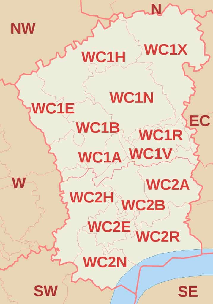
(WC Postcode Area Map by Richardguk via Wikimedia Commons)
How to Know Your Postcode in London
It is easy to know a postcode in London using the Find a Postcode tool of Royal Mail. Simply input a part of the address and the results bar automatically shows some options.
If you want more specific results, you need to enter more information about the address.
With the help of this tool, you can also easily find a business address for well-known companies such as Tesco.
If you can’t find the address you are looking for, it is most likely the property or building you are looking for is new and not yet registered on the database.
Moreover, you may also double-check the spelling and correct abbreviations such as St and Ave.
Did This Guide Help You Find London Postcodes?
London postcodes are straightforward and organized thanks to the list of districts and area coverage. With the help of postcode designations, it is faster to find a location of a business or building.
Sending mail or traveling is more convenient when you know about London postcodes.
Did this guide help you understand more about London postcode areas? Share your thoughts below in the comments section. Don’t forget to share this quick guide with someone you know who needs it.

its only ever a Postal Code, not a Zip Code. Your heading should be Postal Codes and (zip code) also add in to the brackets the rest of the worlds term for Postal Code!!! Thank you.
Hi Baylis,
Thanks for your advice, people who don’t know the Postal Code would use zip code to search.
Here in 🇨🇦, it’s also a postal code 🤗
Hi Catherine,
Thanks for letting us know.