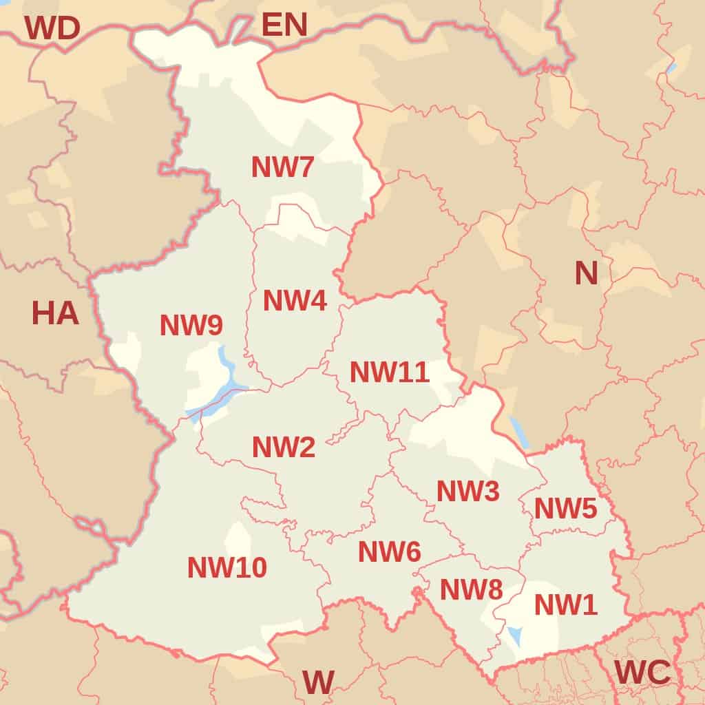
According to data, the North West postcode area or London NW postcode area covers 13,895 live postcodes under 13 postcode districts.
There are 81 postcode sectors covering several London boroughs including Barnet, Brent, Ealing, Harrow, Ealing, Hammersmith and Fulham, Kensington and Chelsea, and the City of Westminster.
It is bounded by several postcode areas such as N, WC, W, HA, and EN.
Check out some other postcodes in London.
- West Central London Postal Codes and Map
- East Central London Postal Codes And Map
- East London Postal Codes And Map
- South London Post Codes (Including South West And South East) And Map
- North London Postcodes And Map
- West London Post Codes and Map
- Full London Postal Codes
| Postcode Area | Postcode District | District and Area (whole or partial coverage) |
| NW | NW1
North Western head District |
ZSL London Zoo, Camden Lock Market, Mornington Crescent, London Marylebone, London Euston, Regent’s Park, Baker Street, Camden Town, Somers Town, Primrose Hill and Lisson Grove, St. Pancras International, Park Square |
| NW1W | NW1 PO Box | |
| NW2
Cricklewood District |
Cricklewood, Gladstone Park, Dollis Hill, Childs Hill, Golders Green, Brent Cross, Willesden Green, Neasden, Kilburn | |
| NW3
Hampstead District |
Hampstead, Belsize Park, Frognal, Childs Hill, South Hampstead Heath, Kenwood, Swiss Cottage, The Hill Garden and Pergola, Primrose Hill, Chalk Farm, Gospel Oak, Keats House, Parliament Hill Viewpoint | |
| NW4
Hendon District |
Middlesex University London, West Hendon, Sunny Hill Park, Windsor Open Space, Hendon, Brent Cross | |
| NW5
Kentish Town District |
Kentish Town West, Kentish Town, Hilldrop Estate, Camden Town, Gospel Oak, Dartmouth Park, Chalk Farm, Tufnell Park | |
| NW6
Kilburn District |
Kilburn Grange Park, North Maida Vale, Kilburn High Road, Brondesbury, West Hampstead, Queen’s Park, Kensal Green, South Hampstead, Paddington Old Cemetery | |
| NW7
Mill Hill District |
Mill Lane, Inglis Barracks, Greenvue venue, Highwood Hill, Mill Hill East | |
| NW8
St John’s Wood District |
St John’s Wood, Lord’s Cricket Ground, Abbey Rd, Finchley Rd, Lisson Grove | |
| NW9
The Hyde District |
The Hyde, Fryent Country Park, Colindale, Kingsbury Green, West Hendon, Wembley Park, Queensbury | |
| NW10
Willesden District |
Willesden, Willesden Junction, Harlesden, Kensal Green, Kensal Rise, Brent Park, College Park, Stonebridge, North Acton, West Twyford, Neasden, Park Royal | |
| NW11
Golders Green District |
Hampstead Heath Extension, Golders Green, Golders Hill Park, Temple Fortune, Hampstead Garden Suburb, Hendon, Finchley Rd | |
| NW26 | NW10 PO Box |
North West London Postcodes Map

(NW Postcode Area Map by Richardguk via Wikimedia Commons)
Further Reading for UK postcodes.
- To learn more about Zip Code In The Uk, Check out our detailed guide to Uk Postcode.
- Check out our guide to London Postcode which you can learn how the London postcode works.
- Want to learn how to write a postcode in the UK? Here is our guide to the UK postcode format.
- Download the UK Postcode Map in case you want to check the postcode in the UK offline.
- Here is a list of Area Postcodes UK if you want to check the area postcodes quickly.


