Do you know your Postcode? You can easily check whether the postcode area is inside the Congestion Zone via TFL here.
- To know more about London postcodes, I suggest reading the complete guide to London Zip Code or Postcode.
- Check out our London Congestion Charge Zone Map Guide, you can get a PDF format Map which is Downloadable and Printable.
- Check out our guide to What You Need to Know about London Congestion Charge.
- Use these methods to avoid the Congestion Charge.
The postcodes below are inside the London Congestion Zone.
- EC1
- EC2
- EC3
- EC4
- SE1
- SW1
- W1
- WC1
- WC2
I created the table below to show the districts that the codes cover.
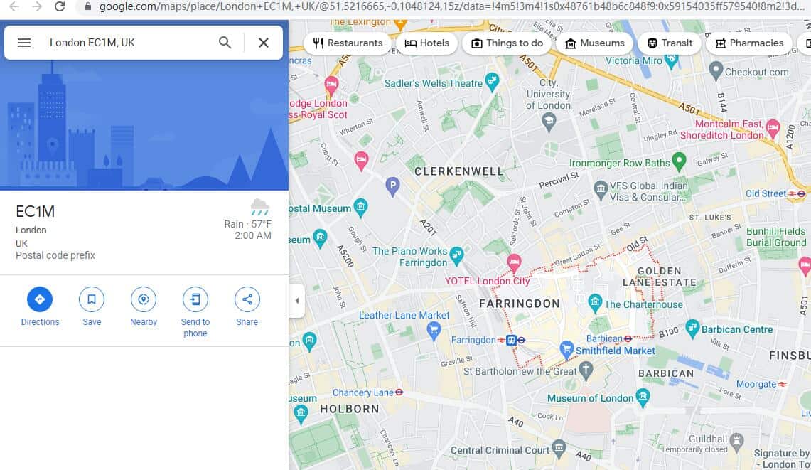
Click the Postcode District to see what areas the code covers from the Map.
For example, if you click EC1M, you can see the district the code covers.
| Postcode Area | Postcode District | District and Area (whole or partial coverage) | |
| EC
|
EC1 Head District
|
EC1A | St Bartholomew’s Hospital, Barbican, St. Bartholomew the Great |
| EC1M | Clerkenwell, Farringdon, Golden Lane Estate, The Charterhouse | ||
| EC1N | Hatton Garden, Charterhouse St. | ||
| EC1P | Non-geographic | ||
| EC1R | Clerkenwell, Finsbury, Finsbury Estate, Roseberry Ave | ||
| EC1V | Finsbury, King Square Gardens, Radnor Street Open Space, Moorfields Eye Hospital, Old Street | ||
| EC1Y | Golden Lane Estate, St Luke’s, Bunhill Fields Burial Ground | ||
| EC2 Bishopsgate
|
EC2A | Shoreditch High Street | |
| EC2M | Liverpool Street, Finsbury Circus Gardens | ||
| EC2N | Old Broad Street, Tower 42, London Wall | ||
| EC2P | Non-geographic | ||
| EC2R | Bank of England, London Wall | ||
| EC2V | Guildhall, Guildhall Art Gallery | ||
| EC2Y | Barbican, Barbican Estate, Moorgate | ||
| EC3 Fenchurch Street
|
EC3A | St Mary Axe, Aldgate, Dukes Pl, White Kenneth St. | |
| EC3M | Lloyd’s of London, Fenchurch Street, The Garden at 120 | ||
| EC3N | Tower Hill, Tower of London, London Wall, American Square | ||
| EC3P | Non-geographic | ||
| EC3R | Monument, Billingsgate, St. Dunstan in the East Church Garden, St. Olave’s Church Hart Street, Fenchurch Street | ||
| EC3V | Cornhill, Leadenhall St., Fenchurch St., Lime Street | ||
| EC4 Fleet Street
|
EC4A | New Fetter Ln, Farringdon St, St. Andrew St, Dr. Johnson’s House | |
| EC4M | St Paul’s Cathedral, St. Paul’s, Mansion House, Central Criminal Court | ||
| EC4N | London Mithraeum, Bank, Mansion House, Puttshack Bank | ||
| EC4P | Non-geographic | ||
| EC4R | Monument, Cannon Street, Monument to the Great Fire of London, Lower Thames St. | ||
| EC4V | Blackfriars, Mansion House, Upper Thames St., Ludgate Hill | ||
| EC4Y | Blackfriars, Blackfriars Upas, City Thameslink, Inner Temple Gardens |
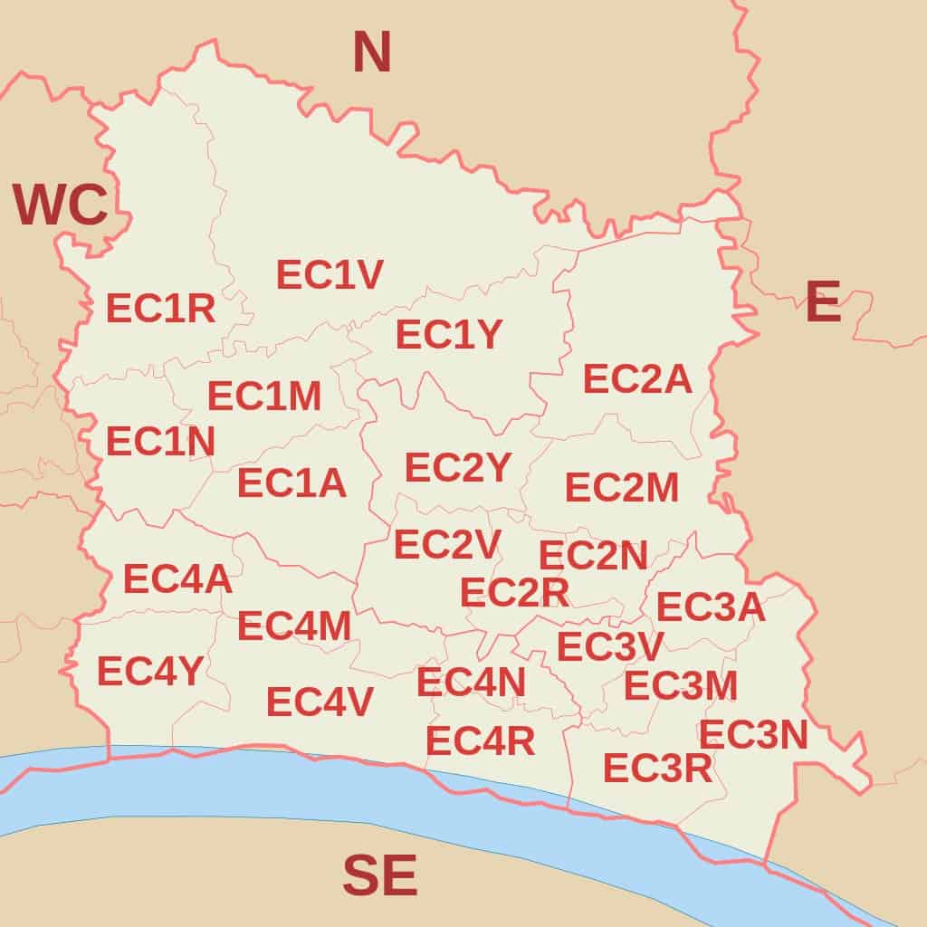
(EC Postcode Area Map by Richardguk via Wikimedia Commons)
| Postcode Area | Postcode District | District and Area (whole or partial coverage) |
| SE | SE1
South Eastern head District |
Bankside, South Bank, Lambeth, Lambeth North, Waterloo, London Waterloo East, Southwark, Borough, Borough Market, Bermondsey, St. Saviours Estate, Vauxhall, Peckham |
| Postcode Area | Postcode District | District and Area (whole or partial coverage) |
| SW | SW1A | Constitution Hill, Buckingham Palace, St James’s |
| SW1E | Westminster, Northern Victoria | |
| SW1H | St James’s Park, Victoria St, Queen Anne’s Gate | |
| SW1P | Victoria Tower Gardens South, Millbank, Westminster Cathedral | |
| SW1V | Pimlico, Churchill Gardens, Vauxhall Bridge | |
| SW1W | Abbots Manor, Victoria Station, Eaton Square Garden of, Belgravia Park, The Royal Mews Buckingham Palace | |
| SW1X | Belgravia, Knightsbridge and Chelsea, Hyde Park Corner | |
| SW1Y | St James’s, Waterloo Gardens |

(SW Postcode Area Map by Richardguk via Wikimedia Commons)
| Postcode Area | Postcode District | District and Area (whole or partial coverage) |
| W | W1A | WI PO Boxes and Admail codes |
| W1B | Portland Place, Regent Street | |
| W1C | Oxford Street | |
| W1D | Soho, Chinatown, Soho Square | |
| W1F | Soho | |
| W1G | Harley Street | |
| W1H | Marylebone | |
| W1J | Mayfair, Piccadilly Circus, Green Park | |
| W1K | Mayfair, Grosvenor Square | |
| W1S | Burlington Estate, Piccadilly | |
| W1T | Fitzrovia,Goodge Street, Tottenham Court Road | |
| W1U | Marylebone | |
| W1W | East Marylebone, Great Portland Street, Fitzrovia |

(W Postcode Area Map by Richardguk via Wikimedia Commons)
| Postcode Area | Postcode District | District and Area (whole or partial coverage) |
| WC | WC1A | New Oxford Street |
| WC1B | Bloomsbury Square Garden, British Museum, Russell Square | |
| WC1E | SOAS University of London, University of London, University College London | |
| WC1H | St Pancras, Russell Square, Gordon Square | |
| WC1N | Russell Square, Great Ormond Street | |
| WC1R | Red Lion Square Gardens, Gray’s Inn Square and South Square Gardens | |
| WC1V | Chancery Lane, Holborn, High Holborn | |
| WC1X | Pentonville, Kings Cross, Finsbury, Clerkenwell | |
| WC2A | Lincoln’s Inn Fields, Sir John Soane’s Museum, Royal Courts of Justice, Chancery Lane | |
| WC2B | Holborn, Lincoln’s Inn Fields | |
| WC2E | Covent Garden, Royal Opera House | |
| WC2H | Covent Garden, Leicester Square, The National Gallery | |
| WC2N | Charing Cross, Embankment | |
| WC2R | Charing Cross, Somerset House, Temple, Two Temple Place |
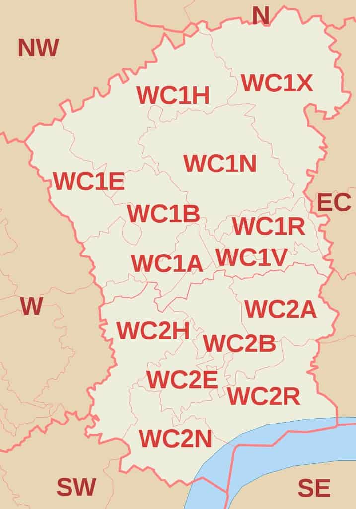
(WC Postcode Area Map by Richardguk via Wikimedia Commons)
Further Reading for UK postcodes.
- To learn more about Zip Code In The Uk, Check out our detailed guide to Uk Postcode.
- Check out our guide to London Postcode which you can learn how the London postcode works.
- Want to learn how to write a postcode in the UK? Here is our guide to the UK postcode format.
- Download the UK Postcode Map in case you want to check the postcode in the UK offline.
- Here is a list of Area Postcodes UK if you want to check the area postcodes quickly.