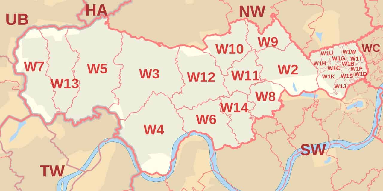
The W postcode area is used by parts of Central and Western London, specifically several boroughs such as Westminster, Camden, Kensington and Chelsea, Ealing, Hounslow, Hammersmith and Fulham, and Brent.
It is linked to other postcode areas including HA, SW, WC, NW, UB, and TW.
The London W postcode area has 35 postcode districts, 217 postcode sectors, and 18,554 live postcodes.
Check out some other postcodes in London.
- West Central London Postal Codes and Map
- North West London Postcodes And Map
- East Central London Postal Codes And Map
- East London Postal Codes And Map
- South London Post Codes (Including South West And South East) And Map
- North London Postcodes And Map
- Full London Postal Codes
| Postcode Area | Postcode District | District and Area (whole or partial coverage) |
| W | W1A | WI PO Boxes and Admail codes |
| W1B | Portland Place, Regent Street | |
| W1C | Oxford Street | |
| W1D | Soho, Chinatown, Soho Square | |
| W1F | Soho | |
| W1G | Harley Street | |
| W1H | Marylebone | |
| W1J | Mayfair, Piccadilly Circus, Green Park | |
| W1K | Mayfair, Grosvenor Square | |
| W1S | Burlington Estate, Piccadilly | |
| W1T | Fitzrovia,Goodge Street, Tottenham Court Road | |
| W1U | Marylebone | |
| W1W | East Marylebone, Great Portland Street, Fitzrovia | |
| W2
Paddington head District |
Paddington, Royal Oak, Bayswater, Queensway, Hyde Park Estate, Kensington Gardens, The Lancasters, Hallfield Estate | |
| W3
Acton District |
Acton, West Acton, North Acton, South Acton, East Acton, Park Royal, Gunnersbury Park | |
| W4
Chiswick District |
Chiswick, Chiswick Park, Gunnersbury, Turnham Green, Acton Green, Stamford Brook, Bedford Park | |
| W5
Ealing District |
Ealing, South Ealing, Ealing Common, Ealing Broadway, North Ealing, Park Royal, Hanger Lane | |
| W6
Hammersmith District |
Fulham, Hammersmith, Baron’s Court, Ravenscourt Park, Stamford Brook | |
| W7
Hanwell District |
Hanwell, Boston Manor | |
| W8
Kensington District |
Kensington, Kensington Palace, Holland Park | |
| W9
Maida Hill District |
Maida Hill, Warwick Avenue, Maida Vale, West Kilburn | |
| W10
North Kensington District |
North Kensington, Kensal Town, Latimer Road, Ladbroke Grove, Kensington Memorial Park | |
| W11
Notting Hill District |
Notting Hill Gate, Ladbroke Grove, Westbourne Park, Holland Park | |
| W12
Shepherds Bush District |
Shepherd’s Bush, White City, Wood Lane, Wormwood Scrubs, East Acton | |
| W13
West Ealing District |
West Ealing, Northfields | |
| W14
West Kensington District |
West Kensington, Kensington Olympia |
West London Postcode Map

(W Postcode Area Map by Richardguk via Wikimedia Commons)
Further Reading for UK postcodes.
- To learn more about Zip Code In The Uk, Check out our detailed guide to Uk Postcode.
- Check out our guide to London Postcode which you can learn how the London postcode works.
- Want to learn how to write a postcode in the UK? Here is our guide to the UK postcode format.
- Download the UK Postcode Map in case you want to check the postcode in the UK offline.
- Here is a list of Area Postcodes UK if you want to check the area postcodes quickly.


