Finding ways to take a break from the fast-paced lifestyle of London? What better way to have a breather than by connecting with mother nature?
One of the best ways to immerse yourself in the planet’s beauty is by having a relaxing coastal walk.
Although coasts and beaches are not commonly found in London, you can always go on a scenic drive outside London and visit the nearby beaches.
In this article, we list our top 10 coastal walks near London that are just approximately two hours away by car or public transport. The coastal areas in this article are perfect for easy to challenging walks.
Whether you are going on a short or long trip, use this article to serve as your guide on where to go.
The article has made it easy for you to find its location through Google Maps links and step-by-step directions from Central London.
Moreover, you can also find top attractions in the area to make your trip worthwhile.
The top 10 coastal walks near London are:
- Seven Sisters
- White Cliffs of Dover
- Mersea Island
- Folkestone, Kent
- Hastings
- Rye
- Brighton
- Blakeney, Norfolk
- Margate
- Ramsgate
- Deal
Contents
1. Seven Sisters
Where: Google Maps Location
Distance from Central London: 73.6 miles to 102 miles
Travel Time via Car: 2 hours and 19 minutes to 2 hours and 22 minutes
Travel Time via Public Transport: 2 hours and 31 minutes to 2 hours and 37 minutes
Driving Directions from Central London:
Via M23
- Take A3212 and Albert Embankment to Peckham – Camberwell – Vauxhall – Westminster Hwy/A202/A3036 in Vauxhall
- Take A23, M23, A23, A27 and A26 to B2109 in Newhaven
- Take A259 to Beachy Head Rd
Via A267
- Take A3211 to E Smithfield/A1203
- Take A13, A282, M25 and A21 to Pembury Rd/A264 in Kent
- Take A267 to Hailsham Bypass/A22 in East Sussex
- Continue on A22 to Polegate
- Take Jevington Rd to Beachy Head Rd
Via A21 and A267
- Take A3211 to E Smithfield/A1203
- Continue on A1203. Take A102, A20, M25 and A21 to Pembury Rd/A264 in Kent
- Take A267 to Hailsham Bypass/A22 in East Sussex
- Continue on A22 to Polegate
- Take Jevington Rd to Beachy Head Rd
Get great views from the untouched Seven Sisters cliffs. It is famous for being one of the longest coastal walks in the world on the English Channel coast in the county of East Sussex.
The name was inspired by its seven distinct hilltops that form the cliffs.
From west to east, the seven cliffs are Haven Brow, Short Brow, Rough Brow, Brass Point, Flagstaff Brow, Bailey’s Hill and Went Hill.
Travelling through the seven sisters is just eight miles or 13 km in total and is about a six-hour walk. While you’re there, you can visit some popular landmarks such as:
- National Trust – Birling Gap and the Seven Sisters
- Robertson War Memorial Bequest Obelisk
- Cuckmere Haven
- Seaford Head Nature Reserve, Sussex Wildlife Trust
- Seaford Museum of Local History
- Seaford Head Golf Course
- Beachy Head Cliffs
- Beachy Head Lighthouse
- The Beachy Head Story
- Towner Eastbourne
- The William Charles Campbell Monument
2. White Cliffs of Dover
Where: Google Maps Location
Distance from Central London: 78.8 miles to 83.2 miles
Travel Time via Car: 1 hour and 44 minutes to 1 hour and 49 minutes
Travel Time via Public Transport: 2 hours and 7 minutes to 2 hours and 35 minutes
Driving Directions from Central London:
Via M2 and A2
- Take A1203, A102 and A2 to M2 in Shorne
- Follow M2 and A2 to A258 in Guston
- Continue onto M2 (signs for Dover/Channel Tunnel/Canterbury/Chatham)
- At junction 7, take the A2 exit to Canterbury/Dover/Channel Tnl
- At Brenley Corner, take the 4th exit onto Boughton Bypass/A2
- At Whitfield Roundabout, take the 2nd exit and stay on A2
- Continue on A258
- At Duke Of York’s Roundabout, take the 3rd exit onto A258
- Turn left onto Upper Rd
Via A13, M2 and A2
- Get on A282 in Grays from A3211, A1203 and A13
- Follow A2, M2 and A2 to A258 in Guston
- Continue onto A282
- Keep right to stay on A282, follow signs for M20/M23/Gatwick Arpt/M25/channel Tunnel/Dover
- Keep right to stay on A282
- Use the left lane to take the A2 ramp to M2/Canterbury
- Keep left at the fork and merge onto A2
- Continue onto M2 (signs for Dover/Channel Tunnel/Canterbury/Chatham)
- At junction 7, take the A2 exit to Canterbury/Dover/Channel Tnl
- At Brenley Corner, take the 4th exit onto Boughton Bypass/A2
- At Whitfield Roundabout, take the 2nd exit and stay on A2
- Continue on A258
- At Duke Of York’s Roundabout, take the 3rd exit onto A258
- Turn left onto Upper Rd
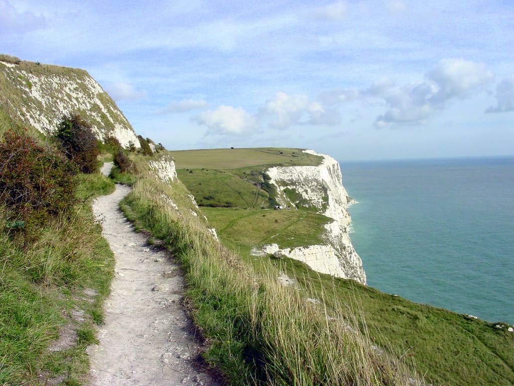
White Cliffs of Dover has a majestic height of 350 ft from the coast. From the White Cliffs of Dover, you can get a magnificent view of the Strait of Dover.
Dover Beach and St Margaret’s Beach are some of the beaches there for a relaxing coastal walk.
Head over to the trail near Deal Kent and begin a 9.5-mile walk, which takes 4 hours and 5 minutes to complete.
An easy to moderately challenging route makes it the perfect place for birdwatching and walking. Don’t forget to check out several historical landmarks, castles, and lighthouses:
- National Trust South Foreland Lighthouse
- The Great Tower
- Tower
- SE&CR Historic Rail Terminal Building
- Historic Dover
- Dover Castle
3. Mersea Island
Where: Google Maps Location
Distance from Central London: 68.7 miles to 73.5 miles
Travel Time via Car: 1 hour and 43 minutes to 2 hours and 2 minutes
Travel Time via Public Transport: 2 hours and 27 minutes to 2 hours and 41 minutes
Driving Directions from Central London:
Via A12
- Take A3211 to E Smithfield/A1203
- Head east on Northumberland Ave toward Great Scotland Yard
- Turn left onto Victoria Embankment/A3211
- Continue to follow A3211
- Continue onto Byward St/A100
- Follow A13, M25 and A12 to Oak Rd in Essex
- Take Braxted Park Rd, Maldon Rd/B1022, Barnhall Rd, Colchester Rd/B1026, and lastly to Peldon Rd to E Mersea Rd
Via M25 and A12
- Get on M11 in Woodford from A3211, A1203, A1261, A13, and Exit 4
- Take the M11 ramp to Cambridge/Stansted Arpt
- Continue onto M11
- At junction 6, exit onto M25 toward M20/Gatwick Arpt/Dartford Xing
- At junction 28, Use the left 2 lanes to take the A12 W exit to A1023/Romford
- Enter the roundabout
- Exit the roundabout onto the A12 ramp to Chelmsford/Harwich/A120
- Keep right at the fork and merge onto A12
- Take Braxted Park Rd, Maldon Rd/B1022, Barnhall Rd, Colchester Rd/B1026 and Maldon Rd to E Mersea Rd
Via A2 and A12
- Get on A282 in Dartford from A2
- Take M25 and A12 to Oak Rd in Essex
- Take Braxted Park Rd, Maldon Rd/B1022, Barnhall Rd, Colchester Rd/B1026, and Peldon Rd to E Mersea Rd
Mersea Island is on the eastern end of England in Essex, popular for seafood, fishing villages, and picturesque beach destinations.
Take a walk on some of the island’s walking trails at Cudmore Grove Country Park, Grazing Marsh, and East Mersea Flats Nature Reserve. It covers seven square miles and is 68.7 miles to 73.5 miles from Central London.
West Mersea is the starting point for the coast path that stretches along the north coast of Mersea Island alongside the Strood and Pyefleet Channels.
It usually takes about five hours to complete a walk around the island. While you’re there, you can discover the island’s secrets and nearby attractions:
- The Strood Trailhead
- Mondays Marsh Trailhead
- Medieval Cattle Track
- Mersea Island Holiday Park
- Cudmore Grove Country Park
- Play At Cudmore
- Wellhouse CAPS Lake
- Grazing Marsh
- Tudor Blockhouse
- East Mersea Flats
- Pyefleet Creek
4. Folkestone, Kent
Where: Google Maps Location
Distance from Central London: 69.6 miles to 72.6 miles
Travel Time via Car: 1 hour and 49 minutes to 1 hour and 59 minutes
Travel Time via Public Transport: 1 hour and 16 minutes to 1 hour and 43 minutes
Driving Directions from Central London:
Via M20
- Take A3211, A1203, A102 and A20 to M20 in Swanley
- Follow M20 to Castle Hill Bridge in Folkestone.
- Keep right to continue on M20, follow signs for Dover/Channel Tunl/Maidstone
- Keep right to stay on M20
- At junction 13, take the A20 exit to Folkestone
- Take Cherry Garden Ave/A2034 and B2064 to Shorncliffe Rd/A259
- At the roundabout, take the 4th exit onto Castle Hill Bridge
- At Castle Hill Interchange, take the 2nd exit onto Cherry Garden Ave/A2034
- Continue straight onto Beachborough Rd/B2064
- Continue to follow B2064
- Continue onto Shorncliffe Rd/A259
Via A13 and M20
- Take A3211, A1203, A13 and A282 to M25 in Dartford
- Follow M20 to Castle Hill Bridge in Folkestone.
- Keep right to continue on M20, follow signs for Dover/Channel Tunl/Maidstone
- Keep right to stay on M20
- At junction 13, take the A20 exit to Folkestone
- Take Cherry Garden Ave/A2034 and B2064 to Shorncliffe Rd/A259
- At the roundabout, take the 4th exit onto Castle Hill Bridge
- At Castle Hill Interchange, take the 2nd exit onto Cherry Garden Ave/A2034
- Continue straight onto Beachborough Rd/B2064
- Continue to follow B2064
- Continue onto Shorncliffe Rd/A259
Via A20 and M20
- Take A2 and A20 to M20 in Swanley
- Follow M20 to Castle Hill Bridge in Folkestone.
- Keep right to continue on M20, follow signs for Dover/Channel Tunl/Maidstone
- Keep right to stay on M20
- At junction 13, take the A20 exit to Folkestone
- Take Cherry Garden Ave/A2034 and B2064 to Shorncliffe Rd/A259
- At the roundabout, take the 4th exit onto Castle Hill Bridge
- At Castle Hill Interchange, take the 2nd exit onto Cherry Garden Ave/A2034
- Continue straight onto Beachborough Rd/B2064
- Continue to follow B2064
- Continue onto Shorncliffe Rd/A259
Located in Kent, southeast England, Folkestone is a port city along the English Channel. In the 19th and 20th centuries, it was a harbour, shipping port, and an important location for soldiers in World War I.
Today, it is best known for its cliffs above the beach, seaside towns, and thriving arts scene.
Folkestone is just beside the White Cliffs of Dover, 9.6 miles to 11.3 miles away or a 21-minute drive.
If you were to continue the walk from Folkestone to the White Cliffs of Dover, it typically takes 3 hours and 4 minutes to 3 hours and 20 minutes. Here are also some of the top sights to see when you are in Folkestone:
- Folkestone Beach
- Sunny Sands Beach
- Folkestone Camping and Caravanning Club Site
- Battle of Britain Memorial
- Capel-le-Ferne Cliffs
- Folkestone East Cliff and Warren Country Park
- Folkestone harbour
- Butterflies
- The Vinery
- Folkestone Harbour Arm
5. Hastings
Where: Google Maps Location
Distance from Central London: 69.3 miles to 76.0 miles
Travel Time via Car: 2 hours and 7 minutes to 2 hours and 15 minutes
Travel Time via Public Transport: 1 hour and 44 minutes to 2 hours and 29 minutes
Driving Directions from Central London:
Via A21
- Take A3211 to E Smithfield/A1203
- Head east on Northumberland Ave toward Great Scotland Yard
- Turn left onto Victoria Embankment/A3211
- Continue to follow A3211
- Continue onto Byward St/A100
- Take A13, A282, M25 and A21 to Falaise Rd in Hastings
- Continue on Falaise Rd to Hastings
Via A21 and A21
- Take A3211 to E Smithfield/A1203
- Head east on Northumberland Ave toward Great Scotland Yard
- Turn left onto Victoria Embankment/A3211
- Continue onto Byward St/A100
- Take A102, A20, M25 and A21 to White Rock Rd in Hastings
- Continue on White Rock Rd to Hastings
- Turn right onto White Rock Rd
- Continue onto St Margaret’s Rd
- Turn right to Hastings
Via A2 and A21
- Take A3212, A302 and Westminster Bridge Rd to New Kent Rd/A201
- Head east on Northumberland Ave toward Great Scotland Yard
- Turn right onto Great Scotland Yard
- Turn left onto Whitehall/A3212
- Continue to follow A3212
- Turn left onto Bridge St/A302
- Continue to follow A302
- Turn left onto Westminster Bridge Rd/A302
- Continue to follow Westminster Bridge Rd
- At the roundabout, take the 3rd exit onto St George’s Circus/A201
- Continue to follow A201
- Follow A2, M25 and A21 to Falaise Rd in Hastings
- Continue on Falaise Rd to Hastings
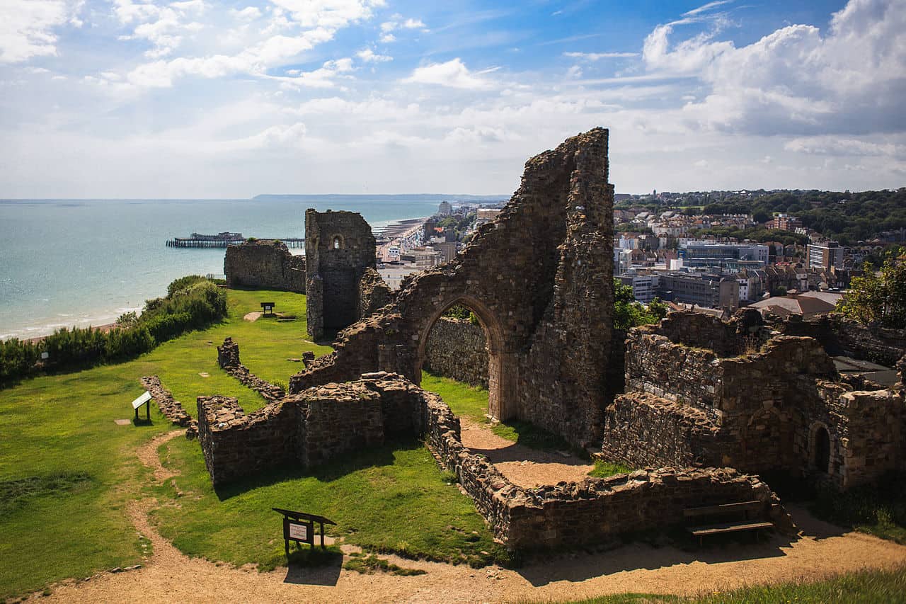
Located on the southeast coast of East Sussex, walking in Hastings is like a walk through history since it is the location of the 1066 Battle of Hastings, now known as Battle Abbey.
It is a vast seaside town home to the picturesque Old Town with charming cottages, vintage boutiques, and cosy inns.
A coastal walk in Hastings leads to East Hill and Ecclesbouren Reservoir, which is a six-kilometre distance.
Enjoy a circular walk at Hastings, ranging from 1.25 miles to 3.5 miles. If you prefer family-friendly walks, head to the seafront going to George Street. However, if you prefer a more challenging route, continue to the top of the East Hill cliffs.
You can keep yourself entertained at several attractions, such as:
- Hastings Pier
- Hastings Visitor Information Centre
- Hastings Beach
- Shipwreck Museum
- Minnis Rock
- Hastings History House
- The 1066 Story
- Hastings Aquarium
- Hastings Museum & Art Gallery
- The Oval
- Leonards On Sea Beach
6. Rye
Where: Google Maps Location
Distance from Central London: 70.5 miles to 78.1 miles
Travel Time via Car: 2 hours and 21 minutes to 2 hours and 23 minutes
Travel Time via Public Transport: 1 hour and 32 minutes to 2 hours and 13 minutes
Driving Directions from Central London:
Via A268
- Take A3211 to E Smithfield/A1203
- Take A13, A282, M25 and A21 to Hawkhurst Rd/A268 in Flimwell
- Follow A268 to Fishmarket Rd/A259 in Rye
- At Skinners Roundabout, take the 2nd exit onto Fishmarket Rd/A259
- Drive to Rock Channel
Via A2
- Take A3212, A302 and Westminster Bridge Rd to New Kent Rd/A201
- Follow A2, M25 and A21 to Hawkhurst Rd/A268 in Flimwell
- Follow A268 to Fishmarket Rd/A259 in Rye
- At Skinners Roundabout, take the 2nd exit onto Fishmarket Rd/A259
- Drive to Rock Channel
Via M20
- Take A2 and A20 to M20 in Swanley
- Follow M20 to Bad Munstereifel Rd/A2070 in Willesborough.
- Keep right to continue on M20, follow signs for Dover/Channel Tunl/Maidstone
- Keep right to stay on M20
- At junction 10, take the A292 exit to Ashford
- Follow Bad Munstereifel Rd/A2070 and A259 to Rock Channel in Rye
Rye is known for many things, from being an entrepôt port, market town, and home to one of the prettiest villages in southeast England.
It is filled with winding cobblestone streets and mediaeval houses. You can continue your coastal walk from Hastings to Rye, with just an 11.7 to 13.7-mile distance.
The walk from Hastings to Rye typically takes 3 hours and 55 minutes to 4 hours and 36 minutes.
However, you can always stay within Rye and walk through easy to challenging routes. You can take the following routes:
- From Peasmarsh to the earthwork remains of Iden Moat
- From the car park in Rye Harbour Village to Rye Harbour Nature Reserve
You may be able to pass by beautiful sights during the walk, including:
- Rye Harbour Nature Reserve (Winchelsea)
- The Lookout
- Whinchelsea Hairpin
- Rye Heritage Centre
- Camber Castle
- Guy Crittall Hide
- Red Roofed Hut
- National Trust – Lamb House
- Rye Harbour Nature Reserve
- Rye Golf Club
7. Brighton
Where: Google Maps Location
Distance from Central London: 53.8 miles to 64.4 miles
Travel Time via Car: 2 hours and 2 minutes to 2 hours and 14 minutes
Travel Time via Public Transport: 1 hour and 16 minutes to 1 hour and 34 minutes
Driving Directions from Central London:
Via A23
- Take A3212, A302, Parliament Sq (entering toll zone)
- At the roundabout, continue straight onto Greycoat Pl/B323
- At the roundabout, take the 1st exit onto Rochester Row/B324 (leaving the toll zone)
- At the roundabout, take the 2nd exit onto Ebury Bridge
- Continue onto Pimlico Rd/A3214
- Continue onto Royal Hospital Rd/B30216 min (2.8 mi)
- Take A3, A243, M25, M23 and A23 to your destination in Brighton
Via M23, A23 and A23
- Take A3212 and A302 to Peckham – Camberwell – Vauxhall – Westminster Hwy/A202/A3036 in Vauxhall
- Follow A23, M23 and A23 to Brighton
- Turn left to reach Brighton
Via M23 and A23
- Take A3212 and Albert Embankment to Peckham – Camberwell – Vauxhall – Westminster Hwy/A202/A3036 in Vauxhall
- Take S Lambeth Rd, Clapham Rd/A3, B221 and A23 to Streatham High Rd/A216 in Streatham
- Take A237 to Brighton Rd/A23 in Coulsdon
- Follow M23 and A23 to Brighton
- Turn left to reach Brighton
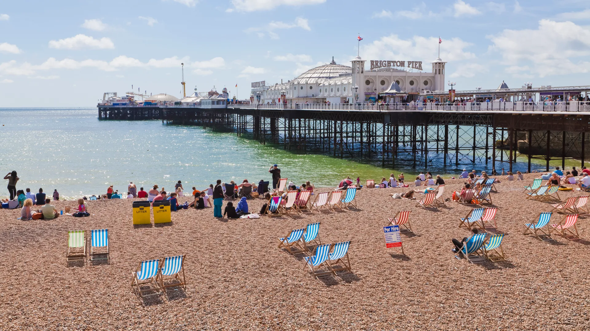
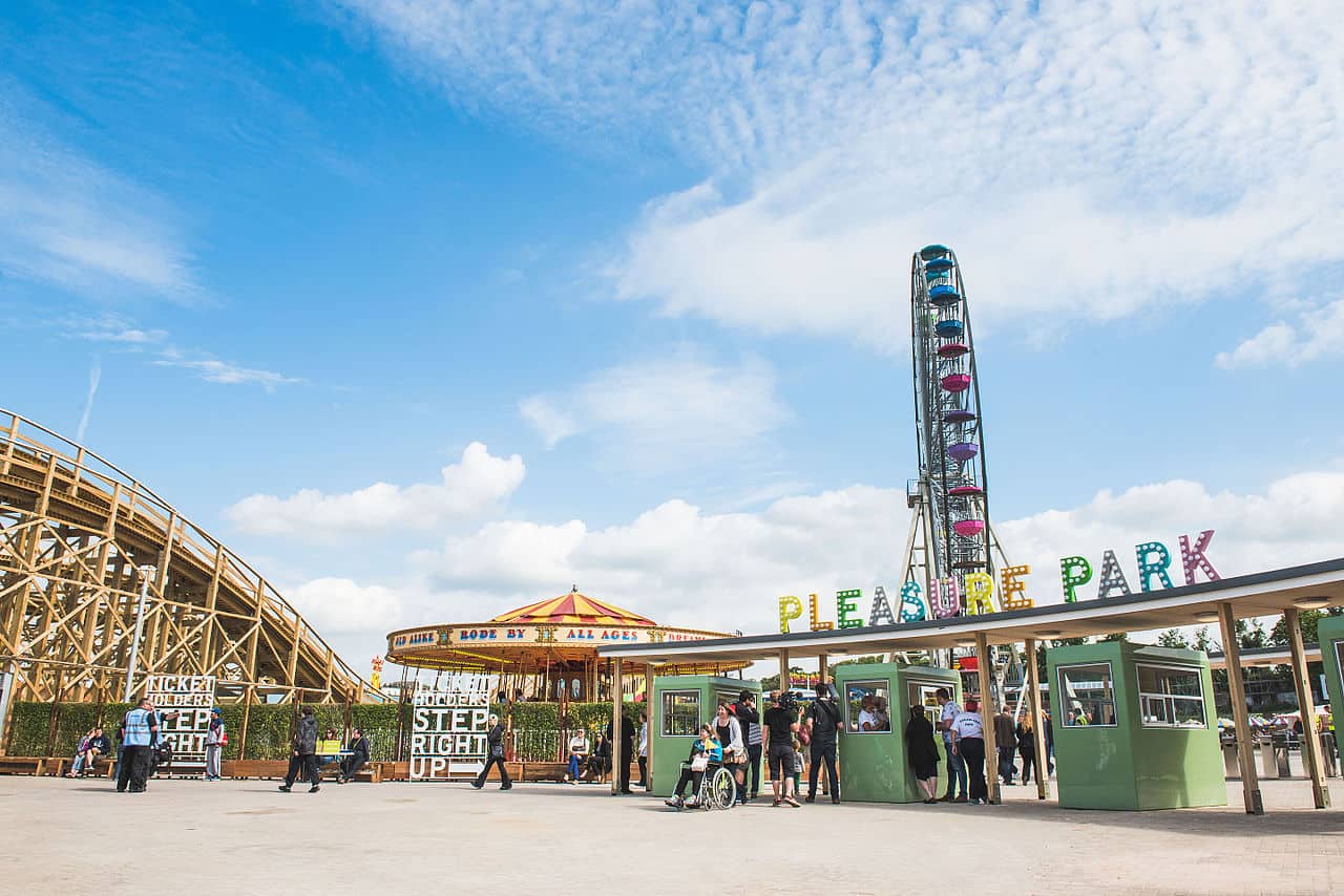
In the south of London, Brighton can be found on the South Coast. Several historical sites, such as the Royal Pavilion, bring you back to the Bronze Age, the Roman period, and the Anglo-Saxon period when you visit this seaside town.
Additionally, Brighton Palace Pier, Brighton i360, and Brighton seafront are great places to see stunning views.
Discover the popular trails in Brighton, from the majestic Undercliff walk along the beaches and cliff bases to a 16.3-km walking trail from Brighton to Southease.
There are also a few routes away from the coast, including Preston Park Circular walks, Castle Hill and High Hill via Queen’s Park, and Stanmer Woods.
While you are there, don’t miss out on fun and attractive places to see, including:
- Brighton Pier Scenic Spot
- Brighton Dome
- Lighthouse
- The Old Market
- The Brighton Centre
- Brighton West Pier
- Victoria Gardens
- SEA LIFE Brighton
- Brighton Palace Pier
- Brighton i360
8. Blakeney, Norfolk
Where: Google Maps Location
Distance from Central London: 134 miles to 140 miles
Travel Time via Car: 2 hours and 49 minutes to 3 hours and 17 minutes
Travel Time via Public Transport: 4 hours and 40 minutes to 5 hours
Driving Directions from Central London:
Via M11
- Take A3211 to E Smithfield/A1203
- Head east on Northumberland Ave toward Great Scotland Yard’
- Turn left onto Victoria Embankment/A3211
- Continue to follow A3211
- Continue onto Byward St/A100
- Continue to follow A100
- Take M11, A11, Newmarket Byp/A14, A11, and then A148 to B1156 in Norfolk
- Continue on B1156.
- Take Saxlingham Rd to Westgate St in Blakeney
Via A11
- Take A4201, Outer Cir and Avenue Road to Adelaide Rd/A41
- Continue on A41. Take A1, A1(M), A505, A11, and A148 to B1156 in Norfolk
- Turn left onto B1156
- Turn right onto Blakeney Long Ln
- Continue onto Saxlingham Rd
- Turn left onto New Rd/A149
- Turn right onto Westgate St going to Blakeney
A little bit farther away from Central London, Blakeney is a coastal village in the English county of Norfolk and northeast of London.
You can find Blakeney within Norfolk Coast AONB and National Trust – Blakeney National Nature Reserve. The coastal walk through Blakeney Point is about 4 miles or 6.4 km.
Blakeney Point coastal walk begins at Cley Beach, Norfolk Wildlife Trust car park. You can walk through the beach if the tide is low.
From the beach, you will pass through the single ridge, the Watch House, the Lifeboat House, and then to the crest of the boardwalk.
Along the way, you will see a seal pup colony and several rare plants, such as horned sea poppy and shrubby sea blite.
Keep in mind that Blakeney Point is home to breeding wildlife; thus, it is strictly not allowed to cross the fences and not disturb the peaceful animals. Instead, appreciate other places in Blakeney, including:
- Bishops Boats Seal Trips
- Blakeney Scout Hut
- Norfolk Coast AONB
- National Trust – Blakeney National Nature Reserve
- The National Trust, Friary Farm
- Blakeney Lodge
- BPAW Creeks of Norfolk-The Home For Waders
- Site of Blakeney Chapel
- Temple Seal Trips at Blakeney Point
- Old Lifeboat House
9. Margate
Where: Google Maps Location
Distance from Central London: 75.9 miles to 81.9 miles
Travel Time via Car: 1 hour and 48 minutes to 1 hour and 52 minutes
Travel Time via Public Transport: 1 hour and 54 minutes to 2 hours and 17 minutes
Driving Directions from Central London:
Via A2 and M2
- Take A3211 to E Smithfield/A1203
- Head east on Northumberland Ave toward Great Scotland Yard
- Turn left onto Victoria Embankment/A3211
- Continue to follow A3211
- Continue onto Byward St/A100
- Continue to follow A100
- Take A2, M2, Thanet Way/A299 and A28 to Marine Terrace/A254 in Margate
- Take B2055 and King St to your destination
- At the roundabout, continue straight onto Marine Terrace/A254
- Continue straight onto Marine Gardens/B2055
- Continue to follow B2055
- Turn left onto Hawley St/B2055
- Turn right onto King St
- Turn left onto Walpole Rd
- Turn right to Margate
Margate started as one of the most famous seaside towns in England. It is a top summer destination loved for its sandy beaches and 21st-century old world charm. Have a circular walk along Margate’s beautiful seafront.
Start the walk near the train station and continue east along the beach. Head along Walpole Bay to Palm Bay in Cliftonville and Foreness Point to Thames Estuary.
You will also pass through Botany Bay, a popular spot with stunning views of the chalk cliffs.
The coastal path continues to Kingsgate Bay, Joss Bay, Broadstairs, and Bleak House. You can drop by the following places during your walk:
- Westbrook Bay
- Westbrook Promenade Walking Trail. (Margate)
- Turner Contemporary
- Dreamland Margate
- Margate Caves
- Palm Bay Beach
- Walpole Bay
- Living Museum
- Memorial Fountain
- Margate Harbour Arm
- Margate Beach
10. Ramsgate
Where: Google Maps Location
Distance from Central London: 78.0 miles to 83.3 miles
Travel Time via Car: 1 hour and 50 minutes to 1 hour and 56 minutes
Travel Time via Public Transport: 1 hour and 43 minutes to 2 hours and 20 minutes
Driving Directions from Central London:
Via M2
- Take A3211 to E Smithfield/A1203
- Head east on Northumberland Ave toward Great Scotland Yard
- Turn left onto Victoria Embankment/A3211
- Continue to follow A3211
- Continue onto Byward St/A100
- Continue to follow A100
- Take A2, M2 and A299 to Canterbury Rd E/A255 in Ramsgate
- Continue on A255. Drive to Brunswick St
- At the roundabout, take the 2nd exit onto Canterbury Rd E/A255
- At the roundabout, take the 1st exit onto Nethercourt Hill/A255
- Continue to follow A255
- At the roundabout, take the 2nd exit onto High St/A255
- Continue to follow A255
- Turn right onto King St
- Turn right onto Brunswick St
If you have the time and energy, you can continue your walk from Margate to Ramsgate. Ramsgate is just 5.1 miles to 5.5 miles away, which can be typically reached in 1 hour and 32 minutes to 1 hour and 40 minutes if you pass through Ramsgate Road.
However, if you follow the coast from Margate to Ramsgate, the entire coastal walk is about 2 hours and 30 minutes.
If you are to stay within Ramsgate only, there are several trails you can follow for a nice coastal walk. You can go through these trails:
- Contra Trail from Ramsgate to Pegwell Bay
- From Ramsgate to Broadstairs
Don’t forget to check out the beautiful and interesting places in Ramsgate, including:
- Ramsgate Main Sands
- Ramsgate Tunnels
- King George obelisk
- King George VI Memorial Park
- Winterstoke Gardens
- Ramsgate FC Southwood Stadium
- East Pier Ramsgate
- West Pier Ramsgate
- Ramsgate’s Bandstand
- Ramsgate Festival of Sound
- Royal Ramsgate Marina
- Ramsgate Lighthouse
- Ramsgate Beach
11. Deal
Where: Google Maps Location
Distance from Central London: 82.2 miles to 88.2 miles
Travel Time via Car: 1 hour and 53 minutes to 2 hours
Travel Time via Public Transport: 1 hour and 45 minutes to 2 hours and 14 minutes
Driving Directions from Central London:
Via M2 and A2
- Take A1203, A102 and A2 to M2 in Shorne
- Follow M2 and A2 to Deal Rd/A258 in Guston
- Continue onto M2 (signs for Dover/Channel Tunl/Canterbury/Chatham)
- At junction 7, take the A2 exit to Canterbury/Dover/Channel Tnl
- At Brenley Corner, take the 4th exit onto Boughton Bypass/A2
- Continue to follow A2
- At Whitfield Roundabout, take the 2nd exit and stay on A2
- Follow A258 to your destination in Deal
Via M20
- Take A3211, A1203, A13 and A282 to M25 in Dartford
- Keep right to continue on M25, follow signs for Dover/M20/Channel Tnl/M23
- At junction 3, exit onto M20 toward Dover/Channel Tunl/Maidstone
- Keep right to stay on M20
- Keep right to stay on M20
- Follow A20, Jubilee Way/A2 and A258 to your destination in Deal
Complete your coastal walk from Margate to Ramsgate by passing through one last stop in Deal. It is 12.2 miles to 12.8 miles from Ramsgate, a 4-hour and 12-minute walk. If you are coming from Margate to Deal, it is about a 20-mile distance.
Getting around Deal on foot is a great way to discover the city. There are so many hidden gems to discover that you can only find when you walk around the small and flat city.
Use the Cycling & Walking Map provided by Deal Town Council, which shows several places of interest, national cycle network route 1, footpaths, train lines, and many more.
You can start your coastal walk from Deal Pier, heading towards Sandown Castle Community Garden. You can pass by nearby attractions, such as:
- Deal Pier
- Deal Castle
- Deal Castle Beach
- Deal Memorial Bandstand
- Walmer Castle and Gardens
- Sandown Castle Community Garden
- Solley’s Ice Cream Parlour
- Royal Cinque Ports Golf Club
- Deal Maritime and Local History Museum
- The Kent Mining Museum
- The Waiting Miner
- Cottington Lakes
- B. Priestley blue plaque
- Edward Ardizzone Plaque
- Deal Timeball Tower
What Are Your Thoughts?
Don’t forget to pack the necessities when going on a trip, such as chargers, extra clothes, a first aid kit, a flashlight, caps and sunglasses, and insect repellant, among other things.
Did I miss a walkable coast not mentioned on the list? Share your thoughts by posting in the comments section below. We’d love to hear your suggestions as well!
For Further Reading
If you’re looking for the best places to visit in London, I suggest having a quick read on several Winterville blogs, including:
- 10 Scenic Drives Near London For a Road Trip
- The Most Dangerous Cities and Safest Cities in UK
- 10 Best Anime Shops To Buy Manga In London
- 12 Best Halal Restaurants in London
- Best Brunch In Shoreditch
As a friendly reminder, if you are driving to the coast from London, don’t forget to bring your Driving Licence and be aware of The Drink Drive Limit in the UK.
Know the rules and regulations when driving in London to avoid penalties and offences.
Have an enjoyable walking trip and drive safe!